Science and Technology Partnerships in Coastal Zone Management:
A Sidney, British Colombia Study
K. Conley (Institute of Ocean Sciences) and T. Curran (Canadian Hydrographic Service)
Abstract
Fisheries and Oceans has partnered with numerous other organizations
to monitor a hard-substrate Reef Ball artificial reef in Sidney, British
Columbia. The project arose from community needs, grew to involve science,
technology, and local
industry aspects. The evolution of the project is described. A frank discussion
of the technologies used to date is
included.
Résumé
Peches et Oceans est partenaire avec de nombreuses autres organizations pour
surveiller un récif artificial de
substratum dur a Sidney, Colombie-Britannique. Le projet de récif
artificial est né des besoins de la communauté,
et a évolué jusqu'a impliquer la science, la technologie, et
les aspects de l'industrie locale. L'évolotion de ce projet
est décrite. Une discussion franche des technologies utilisées
jusqu'a present est incluse.
Introduction
In the early 1990's, the Town of Sidney's Economic Development Committee
(EDC) envisioned a pier, the Pier on Bevan, to enhance recreational activities
in the community such as leisurely walking, nature viewing, fishing and SCUBA
diving. With support from the local community, the EDC began planning and
fund-raising for the 180-m long pier, achieving completion of the 90-m long
phase I in mid- 1996. Phase II of the pier is scheduled to be completed in
1998. The town also planned to construct an associated artificial reef to
create hard substrate habitat to attract shrimp, crab, fish and other marine
organisms in order to achieve some of the pier's objectives. Various artificial
reef construction materials were researched, but the town decided on reef
modules called Reef Balls. Two clusters of Reef Balls, one either side of
the pier, were deployed in November of 1996. The two clusters were constructed
of 270 0.67 m high by 1 m diameter balls weighing approximately 225 kg, Another
cluster of Reef Balls is planned for deployment at the end of the completed
pier. Phase II of the reef will be constructed of about 150 of the small-sized
balls used in phase 1 and 150 balls roughly twice the size. Because thefor phasetion of Reef Ball technology was new to the Pacific-Northwest region,
the Reef Ball manufacturer donated the mold necessary to construct the reef
modules used forphase I of the reef. However, the donation was made on the
condition that the artificial reef be monitored at least twice per year for
three years. For monitoring advice, the town had to seek external scientific
expertise through partnership with the Department of Fisheries and Oceans
(DFO) Institute of Ocean Sciences (IOS).
IOS, under policies in the new Oceans Act, initiated a multi-partnered coastal
stewardship program to monitor the colonisation of life onto the artificial
reef The project became known as SPARS, an acronym standing for Sidney
Pier Artificial Reef Science. It was necessary to hire a coordinator to organize
the various volunteer and partnership aspects of the project. Local divers
were recruited with the assistance of a partnership with the
Professional Association of Diving Instructors - Canada (PADI - Canada)
headquartered in Sidney. The first survey dive took place on March 22, 1997,
with the initial training sessions preceding it that same month. The methods
used for the survey dives were developed through SPARS partnership with scientists
from various DFO departments, the Royal British Columbia Museum (RBCM) and
others. The primary objective of the SPARS project is habitat assessment,mainly
through volunteer-conducted survey dives. The secondary objective of SPARS
is to involve and educate the public in marine science issues, including providing
presentations to schools, volunteers for training purposes, and various others.
A third major objective of SPARS is to highlight local industry and
technology.
This paper concentrates on the latter SPARS objective, involvement of the
technology industry. Specifically discussed are the objectives of SPARS,
especially habitat assessment and community education that have been achieved
or approached by creating partnerships with local companies.
From the outset, the multilayered nature of the project was evident. Starting
from the community needs, the underlying science was included. Based upon
those science needs, various technologies were applied. An attempt was made
to use technology solutions provided by local companies and to publicize
achievements on the web, as a lasting advertisement
Reef Ball Technology
The Reef Balls are deceptively simple. They are constructed from concrete specially treated to be non toxic to marine organisms. The Reef Balls are designed with numerous openings, to reduce buoyancy in energetic wave environments and to provide easy egress for marine plants and animals. The Reef Balls are constructed using an exterior mold system and internal air-filled bladder. The bladder can be left in place, such that the Reef Ball can be floated into place by divers or towed behind a boat. In this project, mass production considerations led to the decision to deploy them from a barge, using a crane (Figure 1).
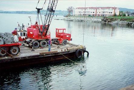
Figure 1. Deployment of Reef Balls via barge and crane
November 13, 1996 adjacent to the Pier on
Bevan, Sidney British Columbia.
The Reef Ball technology is patented, and marketed, through Reef
Ball Development Group Ltd. who donated the molds required to construct the
Reef Balls for phase I of the reef
(http://www.reefball.com). Other
partnerships wore also necessary to construct the Reef Ball reefs. Dart Aerospace
was involved to replicate molds allowing for mass production of Reef Balls.
A local building-supply company, Butler Brothers, partnered with the project
to construct the Reef Balls themselves. Finally, Pacific Pile Driving volunteered
their services to deploy the Reef Balls.
SCUBA Diving
This project uses the sport and technology of SCUBA diving to reach its objective
of habitat assessment, and indirectly to reach its educational objectives.
Although SCUBA (Self-Contained Underwater Breathing Apparatus) is relatively
young as a recreational activity, many advances have made highly
technological gear available to the sport diver. Recreational diver volunteers,
and local dive shops such as Frank White's Dive Stores, have provided the
use of their diving equipment while conducting surveys for the project. Divers
know there is a risk of damaging their equipment every time they dive, but
still are willing to use their sophisticated gear. Equipment has included
everything from divers' basic and advanced personal gear, to underwater
accessories such as dive flags for safety, cameras with advanced lighting
systems, underwater measurement lanyards, and much more. For volunteers who
don't have their own personal gear, Frank White's Dive Stores has provided
equipment rentals as in-kind contributions to the project, including use of
some underwater accessories.
Seafloor Survey
A Kongsberg-Simrad EM3000 acoustic swath Sonar was used to map the area
by the Canadian Hydrographic
Service. The system simultaneously logged range and reflected intensity values.
The area was very difficult to
survey acoustically, because the Reef Ball targets are relatively small,
and they are full of holes. Although the area
was thoroughly ensonified during four successive passes, minor calibration
errors in the motion reference package
meant that only a single pass could be used to construct the digital terrain
model (DTM). This in turn meant that
some areas were poorly identified.
The DTM initially did not reveal any indication of the Reef Balls. In part,
this was due to the low relief, and was addressed by detrending data to remove
the seafloor profile. The The difference has considerable vertical exaggeration.
The resultant image is shown as Figure 2.
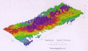
Figure 2. Digital Terrain Model (DTM) of Reef Ball habitat in
waters
adjacent to the Pier on Bevan in Sidney, British Columbia.
Positions were generated using differential GPS from a local reference
station. Perhaps surprisingly, the positioning precision and repeatability
required for coastal zone applications are quite strict. The reason is that
frequently the manager in the coastal zone wants to repeat transects over
time, and submetre accuracies are required.
There was interest in using the reflectivity signal. To date, it has not
been processed, because of other problems encountered.
Physical Measurements
To quantify the biological effects, the oceanographic environment was
monitored using an Aanderaa Current
Meter. The instrument recorded current speed and direction, salinity and
temperature, with a sample interval of 30
minutes. Divers supplied by the Canadian Hydrographic Service shackled the
instrument to a Reef Ball. Refer to
Figure 3.
SPARS Instrumentation Mooring
Sketch
Figure 3. Aanderaa RCM-4 current meter mooring on
Reef Ball reef in waters adjacent to Pier on in Sidney, British Columbia.
Initially, the instrument also telemetered the data to shore, using an
acoustic link. The intention was to permit children on school tours to hear
and observe the data being recorded. However, this feature was not utilized,
and the transducer consumed too much power from the current meter's batteries,
so the use was terminated.
Fouling of the instrument was a significant problem since the site was ideal
for encouraging growth generally. It became an essential task for the volunteer
divers to remove accumulated marine growth regularly, or the current meter
would provide erroneous readings. However, defouling was relatively easy
to arrange during regularly scheduled survey dives.
Underwater Video
Underwater video has been very useful, and has been employed in several
modes, particularly in attaining
education objectives. From the earliest time in the project, diver-held video
has been recorded. Although very
difficult to utilize in a scientific presentation environment, it is nonetheless
very useful. Cameras vary in size and
sensitivity, but all readily available units are suitable.
A local company consortium, including Seaconsult Marine Research in association
with Coastal and Ocean Resources and Archipelago Marine Research, developed
a towed system called Seabed Imaging and Mapping System (SIMS). They plan
to use the SPARS site as a test area, and develop the tool as an adjunct
to their coastal zone classification scheme.
Finally, another company, Cadence Engineering Associates, has recently offered
to provide an in situ underwater camera, and to work with a local communications
company to place continuous video on the Internet. It would also be integrated
into a display at the nearby Sidney museum. There are obvious benefits to
all participants, including publicizing the great educational and habitat
monitoring accomplishments.
Web Site
Much thought went into rewarding those companies and individuals that volunteered
their time to the project. The
concept of a web site was chosen as the vehicle. Web sites also have the
advantage of two-way interaction that
could be used in a variety of ways towards achieving the project's objectives.
Northwest Internet Solutions offered
to host the SPARS site
(http://www.nwis.bc.ca/SPARS).
The same company had already established a site for the
closely related pier project. Actual web site design was the product of a
young computing science student volunteer. It is designed to appeal to the
Internet browser, and provides a wealth of imagery, background,acknowledgements
and links to local companies (see Figure 4).
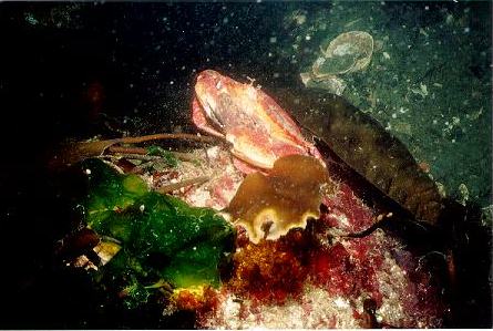
Figure 4. Picture of crabs from SPARS website.
Conclusions
If the habitat creation project is financially constrained, almost everything
can be done with volunteer workers.
However, a paid coordinator is essential to maintain drive and ensure continuity.
Time becomes an unconstrained
variable things take longer because they are volunteered. Partnering loses
many levers - need to cajole rather
than write cheques.
The linkage between technology and habitat is in the early stages. There
is much potential that has yet to be realized.Swath sonar has obvious
application, but better visualization products are needed. Reef Balls were
hard to detect,because they were full of holes. The swath acoustic technology
cannot presently classify marine plants and animals,but the potential is
clear. An early objective was to apply single beam bottom classification
systems to the project,but boat handling considerations made application
difficult in small confined areas.
Hand carried video not easily publishable in conventional media, but is perhaps
the best medium for communication. A towed video system like SIMS has promising
potential for the acoustically tricky Reef Balls, and for
biological classification. In situ video is just getting established. Video
links to other public facilities like the museum can result in synergies and
long term benefit to the community. A web site is potentially invaluable
for all aspects of project. TV on the Internet creates excitement. Two-way
interaction is possible.
Current Meters are very useful to monitor currents, temperatures, and salinity,
and are a first step to linking the physics and biology. Maintenance of moored
equipment can be overcome through project planning.
Divers are a first-class resource. They need continued care and
encouragement.
Municipalities are presently at a scientific, financial, and cultural
disadvantage. A major part of the role of this project is to educate the community
to the practical benefits that can result from community-based science, and
to get the stake holders working together. It is unrealistic to expect significant
initial financial assistance from elected municipal officials. A track record
of successful collaborations needs to be slowly established.
Acknowledgements
The Authors wish to acknowledge the following for their contributions
to this project:
- Department of Fisheries and Oceans: South Coast Division,
- Pacific Biological Station,
- Institute of Ocean Science (Hydrography and Marine Environment and Habitat Science);
- Royal British Columbia Museum;
- Town of Sidney;
- Professional Association of Diving Instructors;
- World Aquatic Sports;
- Frank White's Dive Stores;
- Reef Ball Development Group Ltd.;
- Reef Ball Foundation, Inc.
- Eco-Ed Environmental Youth Team;
- Cadence Engineering Associates;
- Northwest Internet Solutions;
- Archipelago Marine Research;
- Coastal and Ocean Resources;
- Seaconsult Marine Research Limited;
-
Over 40 enthusiastic volunteers.